
Tephrochronology and landscape change in Skaftartunga

| Project Connections: | This project is not linked to any other projects |
Project Details | |
| Title: | Tephrochronology and landscape change in Skaftartunga |
| Permalink: | https://www.nabohome.org/cgi-bin/explore.pl?seq=129 |
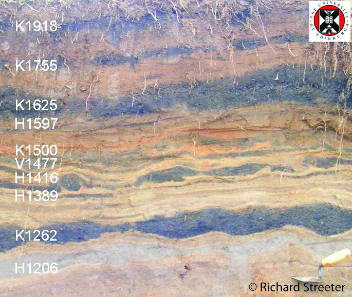
| Abstract: | This project used very high resolution sediment accumulation records to analyse the environmental impact of population changes in this region of Iceland since Landnam, and finished in 2011. The main results are in Richard Streeter\'s PhD thesis and in publications in PNAS and the Holocene (see links below). Skaftartunga has one of the best resolution tephra records in Iceland - tephra layers from Hekla in 1341 and 1389, Katla 1416, Veidivotn 1477, Katla 1500 and Hekla 1597 document the period before, during and after the 15th century with great precision. This is important because this time sees large changes in the form of two plagues in AD 1402 and AD 1494, which kill c30-50% (Karlsson 1996) of the population. Elsewhere in Europe the black death creates an environmental record of land use regression (e.g. Van Hoof et al. 2007) but thus far there has been no attempt to correlate changes in geomorphology in Iceland with these major demographic events.
Through fieldwork in 2008, 2009 and 2010 we have generated a database containing over 220 soil profiles in the region, which consists of nearly 3000 dated tephra layers, and many thousand high resolution (+/- 1mm) photogrammetric measurements of sediment accumulation (further details in the thesis and Holocene paper). This database can be used not only to investigate changes in the period immediately following the plauge in the early 15th Century, but the relationship between population changes and the geomorphic record more generally. By analysing the relationship between climatic records for the region, and population changes over the whole settlement period we hope to begin to quantify how the geomorphic record (which is influenced by many factors) is made. In particular the influence of other major demographic events such as the 1707 smallpox epidemic, 1755 famine and 1783 haze famine will be considered. As part of this analysis agent based population modelling to establish the resilience and recovery time after demographic shock is also being developed.
Initial results indicate that there was an easing of landscape pressure after the first plague in AD 1402, which is seen as a reduction in sediment accumulation rates in the period AD 1389-1416 to levels which are comparable to the pre-Landnam level and the lowest in the post Landnam sequence. While this effect is short lived with rates returning to average post-Landnam rates in the period AD 1416-1477, this easing of landscape pressure may have increased overall landscape resilience. This may explain the lag between climatic deterioration in the 14th century and the geomorphic effects appearing in the late 18th century. |
| Keywords: | tephrochronology,little,ice,age,plague,geomorphology,population |
| Sponsors/Funders: | Natural Environment Research Council |
| Leverhulme Trust | |
| US National Science Foundation; International Polar Year; Humans in the Polar Regions | |
| Country: | Iceland |
| Region: | Skaftartunga |
| Project Start Year: | 2007 |
| Projected End Year: | 2011 |
Account Owner | |
| Contact: | Richard Streeter |
| Institution: | University of St Andrews |
| Postal Address: | Institute of Geography and Sustainable Development
Irvine Building St Andrews |
| Post Code: | KY16 9AL |
| Email: | rts3@st-andrews.ac.uk |
Project Collaborators | |
| Name: | Andrew Dugmore |
| Institution: | Institute of Geography, School of GeoSciences |
| Address: | Drummond Street, Edinburgh |
| Postcode: | EH8 9XP |
| Country: | Scotland, UK |
| Phone: | + 44 (0)131 650 8156 |
| Email: | andrew.dugmore@ed.ac.uk |
| Name: | Anthony Newton |
| Institution: | University of Edinburgh |
| Address: | University of Edinburgh Drummond Street Edinburgh |
| Postcode: | EH89XP |
| Country: | Scotland, UK |
| Phone: | +441316502546 |
| Email: | anthony.newton@ed.ac.uk |
Project Content
|
|
[0.01 MB] Abstract of presentation given for Association of American Geographers annual conference, Washington DC, March 2010. Titled; "Depopulation and its effect on soil erosion in Medieval Iceland". |
|
|
[5.60 MB] Presentation given at the Association of American Geographers annual meeting, Washington DC, 15th April 2010 as part of a session on "Abrupt Change, Scale and Collapse" |
|
[0.91 MB] Annotated photograph of tephra stratigraphy from the 11th Century to present day in the Skaftartunga region. Tephra layers are prefixed by the source of the tephra (H: Hekla; K:Katla; V:Veðivötn) followed by the year AD of the eruption. These represent the most commonly found layers in this area. |
|
|
PhD Thesis from this project (2011) Tephrochronology, landscape and population: impacts of plague on medieval Iceland Unpublished PhD Thesis Richard Streeter (2011) |
|
|
Streeter, R. and Dugmore, A. (2014) Late-Holocene land surface change in a coupled social ecological system, southern Iceland: a cross-scale tephrochronology approach. Quaternary Science Reviews 86, The chronological challenge of cross-scale analysis within coupled socio-ecological systems can be met with tephrochronology based on numerous well-dated tephra layers. We illustrate this with an enhanced chronology from Skaftártunga, south Iceland that is based on 200 stratigraphic profiles and 2635 individual tephra deposits from 23 different eruptions within the last 1140 years. We present new sediment-accumulation rate based dating of tephra layers from Grímsvötn in AD 1432 ± 5 and AD 1457 ± 5. These and other tephras underpin an analysis of land surface stability across multiple scales. The aggregate regional sediment accumulation records suggest a relatively slow rate of land surface change which can be explained by climate and land use change over the period of human occupation of the island (after AD ∼870), but the spatial patterning of change shows that it is more complex, with landscape scale hysteresis and path dependency making the relationship between climate and land surface instability contingent. An alternative steady state of much higher rates of sediment accumulation is seen in areas below 300 m asl after AD ∼870 despite large variations in climate, with two phases of increased erosion, one related to vegetation change (AD 870–1206) and another related to climate (AD 1597–1918). In areas above 300 m asl there is a short lived increase in erosion and related deposition after settlement (AD ∼870–935) and then relatively little additional change to present. Spatial correlation between rates of sediment accumulation at different profiles decreases rapidly after AD ∼935 from ∼4 km to less than 250 m as the landscape becomes more heterogeneous. These new insights are only possible using high-resolution tephrochronology applied spatially across a landscape, an approach that can be applied to the large areas of the Earth's surface affected by the repeated fallout of cm-scale tephra layers. |
|
|
Sediment Accumulation Rate Calculator for Skaftartunga The Tephrabase Sediment Accumulation Rate Calculator automatically produces sediment accumulation rates from the 190 profiles from Richard Streeter's PhD research. These can be used to help understand landscape change in the area since the settlement of Iceland in the 9th century AD. |
|
|
Automatic tephrostratigraphy generation of Skaftartunga profiles on Tephrabase This new tool on Tephrabase will enable you generate up to six tephra sediment profiles at a time from the 190 included in Richard Streeter's PhD research. |
|
|
Reconstructing late-Holocene environmental change in Iceland using high-resolution tephrochronology - paper in The Holocene Paper in The Holoecne published in 2013 which details the photogrammetric approach to recording changes in sediment accumulation in stratigraphic sections. Abstract High resolution records of sediment accumulation are necessary to evaluate subtle temporal and spatial variations in sediment flux, especially in the context of decadal-scale human–environment interactions. Digital photography using consumer-grade cameras may be used to gather thousands of stratigraphic measurements to ± 1 mm (potentially equivalent to ± 2 years of accumulation) and provide data amenable to statistical manipulation. This new approach is illustrated with an evaluation of 15th century landscape change in Iceland. High resolution measurements show that apparent ‘spikes’ in accumulation after episodes of plague are an artefact of lower resolution measurements (± 2.5 mm) over decadal periods. Regional records show little change in sediment accumulation rates after the plagues but key local records made possible using this new methodology reveal that the period ad 1389–1416 (encompassing the plague outbreak of ad 1402) had some of the lowest sediment accumulation rates since settlement of the island. This new approach to landscape assessment indicates that in this pastoralist community the aftermath of human mortality rates of 50–60% saw no development of feral sheep populations or a switch to less labour-intensive wool production. The implication is that cattle production was maintained and the relative easing of landscape impacts could explain the lag between 14th century climatic deterioration and 18th century increases in landscape change. |
|
|
Plague and landscape resilience in premodern Iceland - PNAS paper This 2012 paper in PNAS presents the main results of this project and is part of a special Issue on Critical Perspectives on Historical Collapse, edited by Karl Butzer. |
North East Coordinates: 63.88°N, 18.499°W
South West Coordinates: 63.631°N, 18.739°W