
Inscribing Environmental Memory in the Icelandic Sagas
The Inscribing Environmental Memory in the Icelandic Sagas (IEM) project is a major cross-cutting initiative of The Nordic Network for Interdisciplinary Environmental Studies (NIES), The North Atlantic Biocultural Organization (NABO) and The Global Human Ecodynamics Alliance (GHEA).
Cross-cutting integrative tools and platforms
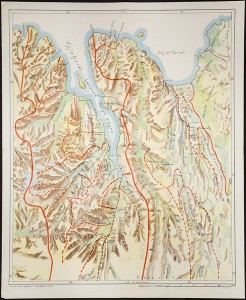
Fig. 1. Hand drawn map showing locations of settlement era chiefly power centers as derived from the Sagas centered upon Eyjafjord (courtesy Gisli Sigurdsson, Árni Magnússon Institute for Icelandic Studies)
The international and interdisciplinary NABO cooperative (founded 1992) has long used maps and place-based analysis tools to facilitate productive collaboration across disciplines. Maps become increasingly useful tools for displaying diverse data sets and promoting the cross-disciplinary recognition of patterns in social and environmental factors that play out in both space and time. While hand drawn maps remain powerful tools for visualization (Figure1), their power increases exponentially with the application of GIS technology backed by highly detailed spatially-referenced data sets (archaeology, place names, historical route ways, past human and animal censuses, shifting power centers, areas of different vulnerability to climate change on different scales, etc.). As another way of inscribing environment and environmental memory, maps have tremendous potential as points of cross-disciplinary interface (even as a kind of methodological lingua franca), enabling greater and greater creative overlaying and stimulation of interdisciplinary conversation and understanding. GIS applications require spatially referenced data sets, and these are becoming increasingly available for Iceland from multiple sources including the FSÍ's ISLEIF archaeological site database used in figure 2.
Map-based presentation and display of a wide range of data sets is becoming increasingly important to international interdisciplinary data curation efforts as well, represented by efforts such as SEAD (the Strategic Environmental Archaeology Database at Umeå University) and the map-based NABO Project Management System. Digital humanities tools and databases can also help to map literary and documentary content so as to allow for innovative analyses of texts and new visualization techniques. In conjunction with other place-based mapping approaches these tools hold great potential for generating new knowledge; therefore those centers where such techniques are being pioneered (e.g. UCLA and Umeå University's HUMlab) have come to be regarded as valuable potential partners/contributing research environments in the IEM initiative. Increasingly place-based digital information is connecting not only different scholarly traditions, but also science and scholarship directly with placed-based heritage and education for sustainability initiatives.
The Icelandic Sagamap Project, developed by Emily Lethbridge, is a great example of how mapping of place names mentioned in literature can help us to reinterpret these sources and provide new insights into the geographical distribution of events within the sagas.
IEM will collaborate closely with the long-established community-based Kids Archaeology Program (KAPI) based in Thingeyjarsysla in North Iceland, which is already collaborating with NABO and the Icelandic Place Name Institute (based at the Árni Magnússon Institute for Icelandic Studies). Read more here. This program has received widespread international recognition for combining heritage conservation with education for sustainability and will partner with the IEM initiative through NABO to provide direct community engagement in sustainability scholarship.
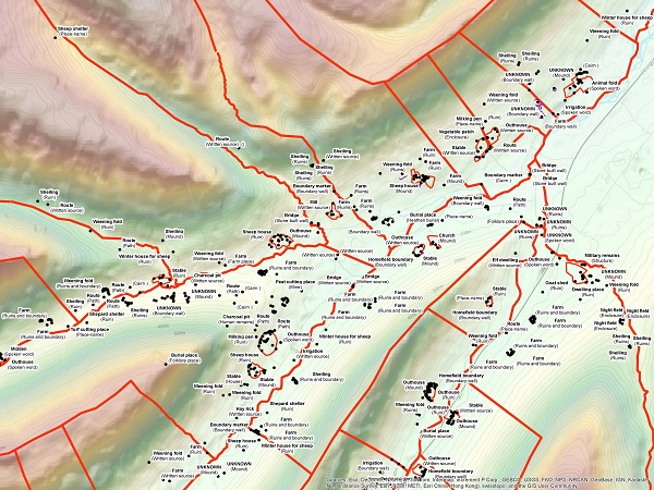
Fig. 2. GIS output locating ruins and routeways in part of Eyjafjord based upon GPS location provided by the ISLEIF archaeological data base maintained by FSI. GIS courtesy of Kenneth Mack, CUNY.